The LiDAR active remote sensing system uses medium power lasers that generates a stream of high-energy particles, termed photons, in a narrow wavelength band. It is capable to collects millions of elevation points per hour– much faster and with greater density than traditional methods.
LiDAR Characteristics
Vertical accuracy for commercial and engineering applications of 15 cm on the discrete points.
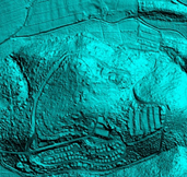
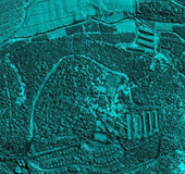
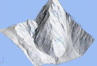
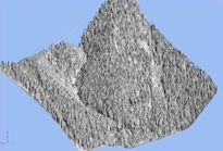
The range measurement process results in the collection of elevation data points arranged systematically in time across the flight line. The LIDAR is capable of collecting millions of elevation points per hour– much faster and with greater density than traditional methods. The LIDAR produces a “Point Cloud” that displays a 3D illustration of the surface and the terrain, visualizing the scanned area.
The LIDAR is capable of capturing multiple returns per pulse.
LiDAR Applications
Detailed Surface Model (DSM) and Detailed Terrain Model (DTM) generation.
Mapping for engineering and infrastucture construction- roads, railway tracks, pipelines, waterway landscapes.
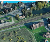
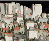
Constructing of 3D model illustrations of the scanned areas using the LIDAR point cloud. Implementation of computerized 3D models in genuine terrain.
Mapping of electrical transmission lines and towers including tree clearance.
Mapping of drainage basins, flood management, slops and water flow directions
Rapid mapping and damage assessment after natural disasters.
Derivation of vegetation parameters.
Scroll to Top
We use cookies to ensure that we give you the best experience on our website. If you continue to use this site we will assume that you are happy with it.