Find Your Way

3D – Mapping

3D - Mapping :

Geomatic offers a complete solution for collecting 3D street level imagery, developing applications, and delivering visually impressive and spatially accurate results for any application.
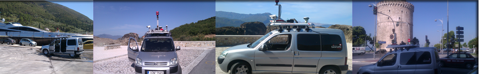
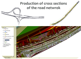
Geomatic Mobile Unit has developed the first truly scalable mobile mapping solution, enabling collection of entire city areas, states or countries in the order of tens or hundreds of thousands of road network. By combining high quality images, high accuracy differential GPS, an IMU unit,and with the latest high resolution 3D panoramic camera (Ladybug3) the result is quantifiably more than just pretty pictures. Now we can deliver 3D data in no time in any format and build unique 3D applications. The system can be mounted on almost any vehicle for the rapid collection of any vehicle accessible area.
Projects:

a. Egnatia Odos / MEBOA 2012

Using our own 3D mobile unit, Geomatic achieved to collect 3d geographical data for 10 states in Greece the suburban road network (more than 5000Km) . Also we have developed standalone software (Geomatic Road Processor) in order to digitize all the street furniture of the suburban road network using videos and image capturing technology combined with GIS. 

We have already delivered these data to the states of Thessaloniki, Imathia, Kefalonia, Kerkyra, Fokida, Aitoloakarnania, Evoia, Voiotia, Magnisia and Trikala.

b. 3D - Ministry of Transportations and Public Works Department

Geomatic was the leader and project coordinator for recording the Trans-European Road Network of Cyprus, and deploy 3D GIS using Stereoscopic Cameras, a project for the Ministry of Transportations for all Highways of Cyprus.

c. The three-dimensional scanning and photography of archaeological monuments and sites at the Archaelogical Museum of Tegea (Prefecture of Arkadia, Greece)

Geomatic performed the capturing of high-resolution panoramic and spherical images with the Ladybug3 spherical digital video camera system (Point Grey), as well as the disposal of appropriate software for managing the image capturing and display . The outcome of the project was the Re-exhibition of the Archaelogical Museum of Tegea through the three-dimensional scanning and photography of the archaeological monuments and sites with panoramic photo systems and the development of the appropriate applications for the integration of the photographs into Microsoft Pixel Sense environment and the website of the museum.

Other Solutions:

Scroll to Top